
Get social with fobif…


-

Twenty Bushwalks in the Mount Alexander Region

Mosses of Dry Forest book
Eucalypts of the region book
Wattles of the region book
Native Peas of the region book

Responding to Country

 The Camp Out on the Mount is on again next weekend, 17-18 October. As well as the Pine Purge on Saturday there are lots of other activities. To find out more click on the poster to the left. There is also more information on the Connecting Country website.
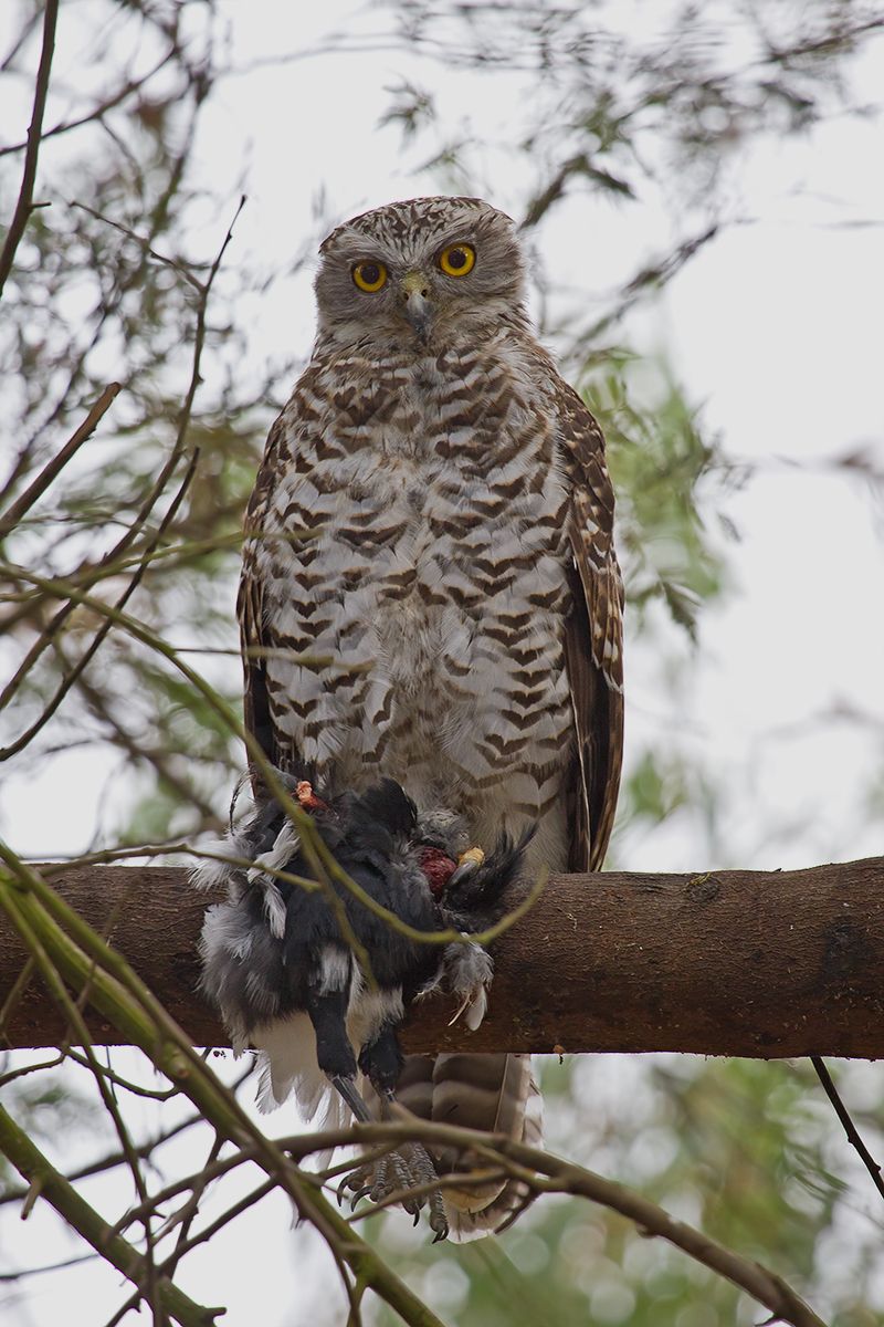
Powerful Owl and prey at Newstead by Patrick Kavanagh.
Newstead residents and readers of the Natural Newstead blog may be familiar with the spectacular and rare Powerful Owls, which have very successfully raised young down by the Loddon River. But what are the lives of these magnificent nocturnal hunters really like? And how do they sustain themselves and feed their young? Newstead Landcare member and PhD student Emmi Scherlies has been researching the lifestyles of these remarkable birds and will let us into their secrets at Newstead Landcare’s October presentation and AGM.
Don’t miss this great opportunity to discover more about Australia’s largest owl. The presentation will be on Thursday October 15th starting at 8pm at Newstead Community Centre and will go for about an hour. A very brief AGM will follow and then some light refreshments. All are welcome to attend. Gold coin donations would be appreciated. Bookings not necessary.
For more information ring Frances Cincotta on 5476 2691 or Patrick Kavanagh on 0437 663 345.
On October 2 DELWP conducted a Zone 1 [Asset Protection] burn in Campbell’s Creek. The area burned was 80 hectares, between Rowley Park Road and Pottery Road. The result, in yellow gum and box woodland with reasonably sparse understorey, appeared to achieve the fuel reduction aims of the exercise…and to perpetrate the usual unnecessary damage, in the form of the unintentional destruction of large trees [see photo at the end of this post].
FOBIF has not objected to fuel reduction close to housing. It should be recalled, however, that these exercises are bound to produce ecologically impoverished environments, or to prevent the recovery of already damaged ones. That’s one very good reason for resisting plans to develop new housing near bushland.
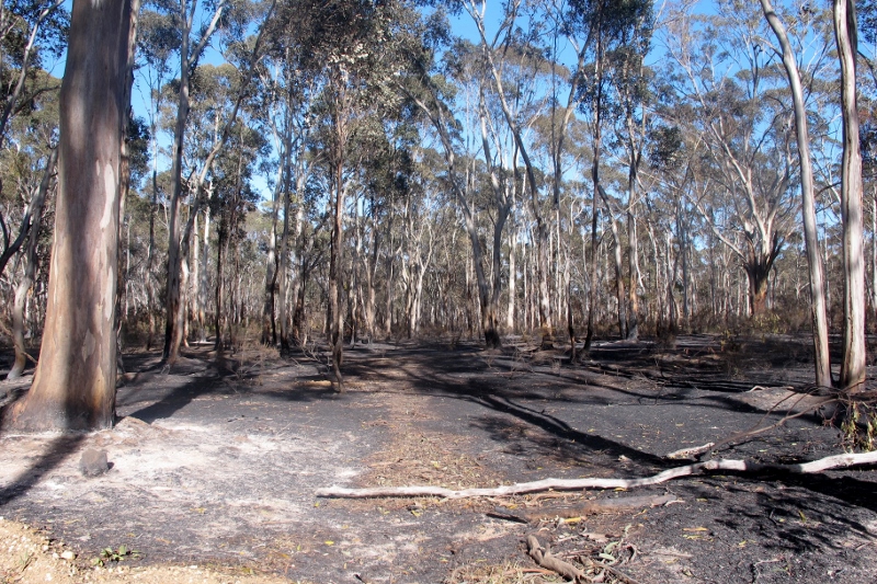
Near Rowley Park Road: fuel reduction exercises like this are ‘ecological sacrifice zones’
A further question about such burns is: how does the fuel reduction target sit with fuel loads on adjacent private land? In the present case, the public land, now bare earth and dust, sits across the road from some heavy infestations of gorse and blackberry, some of it over ten feet high. The much touted Risk Landscape program, launched over the last twelve months, seemed to promise an integrated program of fuel management over public and private land. As far as we can tell, no action has ensued on this ‘tenure blind’ fuel management. We understand that oversee of vegetation on private land is not even DELWP’s responsibility, but that of the Department of Economic Development, Jobs, Transport and Resources (
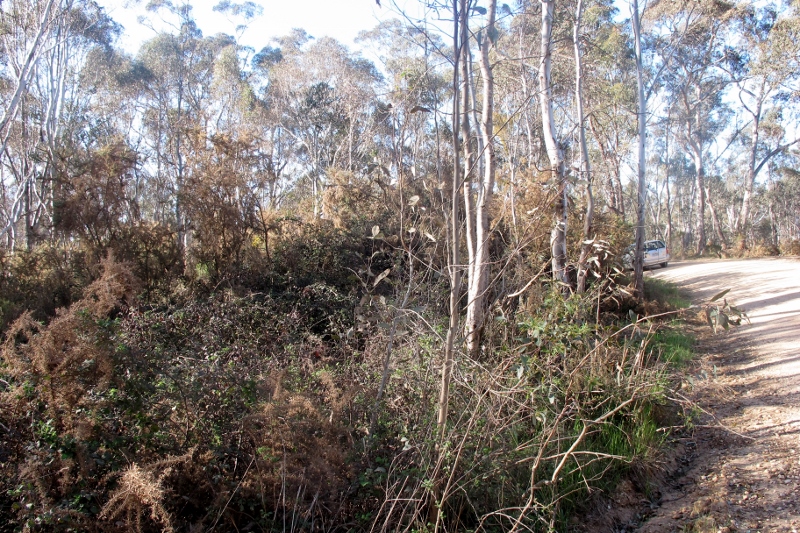
Across the road from the burn zone, the gorse is 10 feet high: the Risk Landscape policy proposes fuel reduction on private and public land, but in practice, only public land is systematically cleared of vegetation.
And, as a footnote to this theme: it has been alleged that the management burn in the Cobaw forest last week was conducted by officers pressured by government policy to achieve a target of land burned under the five per cent policy. We aren’t familiar with the Cobaw area, but find it very hard to believe that officers would take big risks in pursuit of a policy which is supposed to be on the way out. In any case, an independent enquiry into the subsequent bushfire should clarify exactly what happened there, and why.
Nevertheless, it’s worth raising the question: why is the Government taking so long to make a decision on the five per cent burning target? The IGEM recommendation that it be abandoned in favour of a more strategic ‘risk management’ policy was made four and a half months ago. Surely that’s plenty of time for the Minister to decide what to do about that recommendation? The debate on the system of area targets for fuel reduction should be well and truly over.
In the mean time, DELWP is continuing to issue Fire Operations Plans apparently based on this very system.
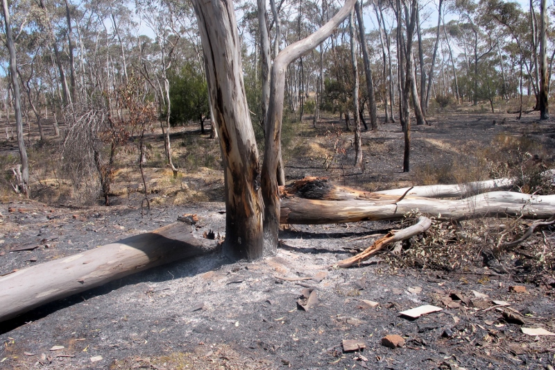
Large trees brought down by management fire in Campbells Creek: the trees here were all about 30 cm in diameter at breast height.
The Federal Department of the Environment estimates that estimated that weeds ‘cost Australian farmers around $1.5 billion a year in weed control activities and a further $2.5 billion a year in lost agricultural production. The real cost of weeds to the environment is difficult to calculate, however it is expected that the cost would be similar to, if not greater than, that estimated for agricultural industries.’
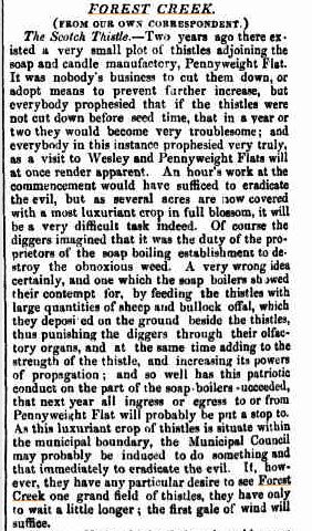
John Ellis has unearthed the item at left from the Mount Alexander Mail, December 1857. The thistle was declared as a noxious weed in Victoria in 1856. Apparently the Mail‘s urgings weren’t heeded, because it’s now Victoria’s most widespread weed , and covers over a million hectares around Australia. Before you get depressed by that figure, it’s worth noting that this is only a fifth of the area it covered before control programs started in the 1960s. Weeds can be fought!
There’s an interesting moral in the Mail‘s sermon, too: get in early, before the problem gets out of hand. If only we’d done that with bridal creeper, for example: a few years ago its spread was a fraction of what it is now. That’s more motivation for those attacking outbreaks of Chilean Needlegrass.
It’s well known that one of the problems with walking on the GDT is the lack of water, which probably discourages some walkers from undertaking ambitious distances on the track.
A small dent in this problem is about to be made, with the launch of the GDT’s FIRST watering point on the Leanganook Track section of the Goldfields Track (between Bendigo and Castlemaine) next Friday [October 16].
It’s located East of the Goldfields Track, next to the Coliban Channel and near the Parks Victoria dry campsite. Mandurang South Road is close by. It’s on map 30 of the Goldfields Track Walking Guide .
Coliban Water is GDTA’s partner in this great initiative and importantly, they have announced that they will ‘host’ the tank for track users. If the system works for walkers and bike riders there’s a chance more tanks will be put in on the track.
The launch will be at 11 am, and it’s catered. FOBIF members are invited to attend: RSVP to Alison Lanigan at gdtatrail@gmail.com
We’ve received a response from DELWP to our questions about the scalping of Fryers Ridge Road. You can read it by clicking here: Fryers Ridge Rd DELWP response
The key paragraph runs as follows:
‘Roadside scalping is sometimes used where the verge needs heavy vegetation and debris removed and the ground profile flattened to allow future maintenance to be carried out by slashing; to widen the mineral earth part of the road as part of planned burning preparation…; and if resource limitations have prevented an annual slashing program to be maintained causing an accumulation of heavy growth on the roadside.’
There are three reasons here, the first two of which do not apply to the Ridge Road. The third, however–the reference to ‘resource limitations’– confirms our suspicions: that scalping is used as a cheap method of achieving your ends when you’re short of cash. So, although it’s generally considered a bad way of going about things, managers are forced to use it anyway.
It’s clear also, from this letter, that roadside clearing often happens in ignorance of what might be getting scraped into oblivion: there’s no effective monitoring of its biodiversity effects. And although managers generally need to comply with clearing regulations, these only come into play if something ‘important’ is known to be in the relevant area. In the absence of detailed monitoring, this often comes down to the judgement of the manager in question.
We have serious disagreements about the decisions made to scalp the Ridge Road, and other tracks in the Fryers Ranges, and believe that in most areas there was no ‘heavy growth’ on the roadsides.
In another communication to us from the Environment Minister, we’ve been invited to discuss values of roadsides with the responsible Terrestrial Biodiversity Manager. We’ll take up this invitation.
The Mount Alexander Shire will be undertaking works on the Guildford Big Tree, which, as we’ve previously reported, was badly damaged in February. From a Council briefing:
‘The severe storm in February 2015 caused considerable damage to the
canopy of this significant tree causing the loss of several large
sections of the canopy. This loss has exposed a number of branches
within the remaining canopy which have the potential to shed during
relatively mild weather conditions.
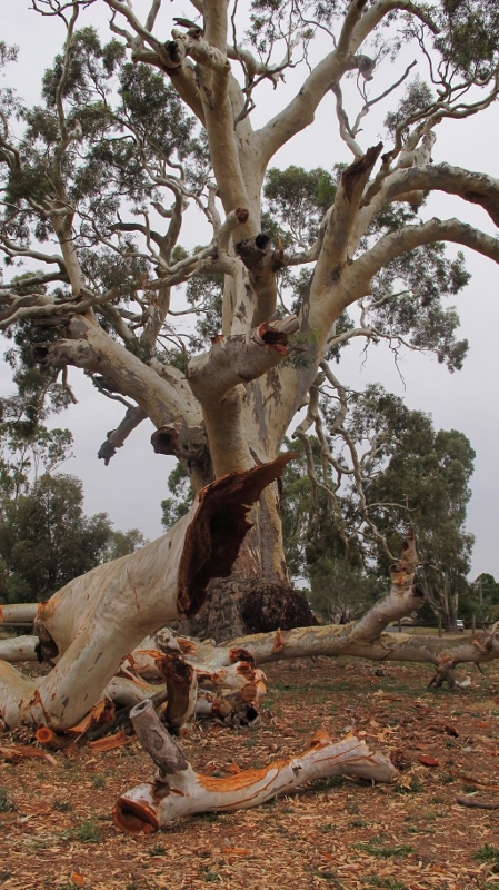
The Big Tree: works will be undertaken to try to forestall further damage to the old feller.
‘To protect the tree, reduce potential branch loss and improve overall
tree health, the following works are scheduled to occur within the
next few weeks:
‘1. The tree will be pruned to reduce over-extended and exposed
branches. The pruning will reduce the potential hazard associated
with these branches and leave a well-balanced tree with an
aesthetically pleasing appearance. All pruning will be undertaken in
accordance with Australian Standards, AS4373-2007 Pruning of amenity
trees.
‘2. Several large branches that remain below the tree will be relocated
from beneath the trees canopy and remain on-site as informal seating
for visitors. Some of the other branches will be taken to Guildford
Primary School. Any other remaining branches will be removed.
‘3. The existing grassed area beneath the tree will be mulched.
Mulching of the existing grassed area will reduce root competition for
soil moisture and nutrients, prevent soil compaction by mowing
equipment and improve tree health.’
FOBIF has made a submission to the Tarran Valley rezoning advisory committee. This committee has been appointed by the planning minister, Richard Wynne, to consider a proposal to develop land in the Sandy Creek area near Maldon. We have objected to the development. Our submission can be found here.
This matter dates back to 2006, and our background posts on it can be found by tapping Tarran Valley into the search box at top right of this page.
Our objections relate to fire risk and development in catchment areas. We also point out that population trends used by Council in its original decision to approve the development were significantly exaggerated: ‘[The Mount Alexander Urban Living Strategy 2005] has a population projection for 2021 of 21,930, compared with the more realistic population projection of 19,291 from the Victoria in Future [VIF] 2015 study. The urban living strategy thus over estimates the population, in comparison to VIF, by 2,639 which translates to an over estimation in housing lots needed at this date of over 1,000 lots.’
The committee will report to the minister in due course–possibly not till next year.
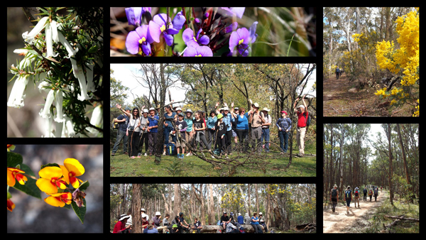
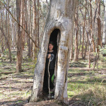
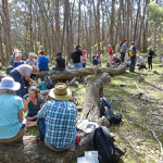
Noel Young sent us this report on the September FOBIF walk:
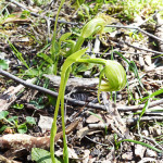
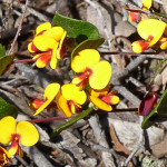
True to its name the Wattle track was rich with flowering wattles. In pleasantly mild conditions, walkers covered nine and a half kilometers through a variety of bush with many plants awakening to flower a little late after a cool dry winter. The flowers I managed to list were Downy Grevillea, Early Nancy, Hovea, Billy Buttons, Purple Coral-pea, Guinea flower, Handsome Flat-pea, Grey Parrot-pea, Common Heath, Common Beard-heath, Pink Bells, Gorse Bitter-pea, and the only orchid found – a patch of Nodding Greenhoods.
Birds were abundant along the way, their presence mainly indicated by calls. I listed those I could recognise as: Spotted Pardalote, White-throated Treecreeper, Crimson Rosella, Sulphur-crested Cockatoo, Grey Shrike-thrush, Fuscous Honeyeater, Superb Blue Wren, Long-billed Corella, and Grey Fantail. Others added Galah, Oriole, and Yellow-faced Honeyeater.
Liz Martin sent us this photo collage.
And here are some photos from Dominique Lavie (first photo) and Noel (last 3 photos). Click to enlarge.
![]()
")
White Everlasting Daisy (Chrysocephalum baxteri)

Slime Mould

Dunns Reef

Tall Greenhoods

Gnat Orchid

Blue Caladenia
")
Downy Grevillea (Grevillea alpina)

Coliban river upstream of the Gibbons bridge

Coliban river upstream of the Gibbons bridge.

Coliban river upstream of the Gibbons bridge.

Sailors Gully ruin

Loddon River near Vaughan

Cortinarius archeri

Mycena subgalericulata

Cortinarius rotundisporus

Cortinarius cystidiocatenatus,

Ramaria sp.

Pink Heath

Mount Alexander

Mount Alexander
 Click on image for info/order page
 Click on image for info/order page
 Click on image for info/order page