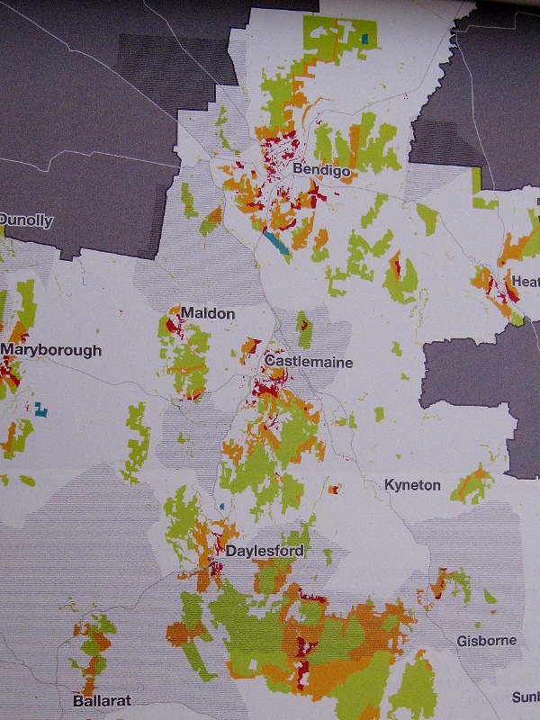
Strategic bushfire management plan: West Central bushfire risk landscape. DEPI 2014
This document has been anticipated with some interest—as have its companions, the plans for the East Central and Barwon Otways districts. It was launched at last Friday’s Creswick conference by Lee Miezis, DEPI’s Executive Director, fire and emergency management– with some suggestion that it promised a new improved approach to fire management.
The promise is still there: there’s no doubt that careful risk assessments and computer modelling of bushfire behaviour could enormously improve our capacity to deal with bushfires. This document disappoints in the delivery, however.

Fuel management map: the mid grey areas are ‘priority fuel management areas’. In our area they’re north and west of Castlemaine, Maldon and the Midland Highway. 40% of planned burning on public land will be in these areas…which are mostly private land.
Its first problem is that it largely confines its consideration of risk to the matter of fuel and fuel management. On page 31 of a 33 page document we’re told that fuel management is ‘only one of a range of approaches to reduce bushfire risk on public land.’ The others include prevention, preparation, response and recovery.
You’d think the first of these [‘prevention, to minimise the occurrence of bushfires, particularly those started by people’] would be a high priority, given that most fires are started by people [in the Mount Alexander shire there are an average of 53 fires a year, and only 6 of these are naturally occurring. 42% of fires dealt with by DEPI since 1972 have been accidents, 35% were deliberate, and 17% ‘unknown or other causes’]. It will be dealt with ‘over the next few years’. In the mean time we have a range of advertising and punitive measures with a limited success record. Priority is given to fuel, and the community is given to understand that its management is the main way to reduce risk.
You’d also think that a major risk is housing in dangerous areas. This is referred to in passing on page16, then forgotten.
The second problem is that in practical terms the plan is perfectly vague. This is partly because a 33 page document dealing with a region which stretches from the outskirts of Geelong to beyond Huntly, and from Melbourne’s western fringe to north west of Dunolly could only deal in the most general way with the problems it’s confronting.
So, if you’re hoping to get an idea from this document as to how stuff is going to happen on the ground, forget it. What we get is some useful info about fire behaviour, with a few vague gestures about fuel management: and remember, whatever the computer modelling and risk assessments say, DEPI has still been directed to burn to its target.
Among the useful info in the document is the above map, with the mid grey hatched areas showing ‘priority fuel management areas’:
The text comments:
‘We will ensure that at least 40% of all planned burning each year on public land is in the priority fuel management areas.’
This is quite a baffling comment, given that in our area these areas are overwhelmingly on private land. The text adds, however:
‘The strategy does not preclude fuel management outside priority fuel management areas: fuel management will continue to occur across the landscape (except in planned burn exclusion zones), informed by finer-scale analysis of bushfire risk to various assets from less-severe bushfires. For example, we will manage fuels outside priority fuel management areas (as identified in fire operations plans) north and west of Daylesford–Hepburn Springs, Castlemaine, Bendigo, Kyneton and Heathcote to reduce risk to towns, infrastructure and economic activity.’
We’re resigned to business as usual—for the immediate future at least.


 Click on image for info/order page
 Click on image for info/order page
 Click on image for info/order page


